Initial Assessment of Don Chao Poo,
Amphur Phana, Amnat Charoen Province, Thailand
Phana Monkey Project
Researchers:
E. Capp, R.L. Cope, C. O’Brien & R.J.Southon
1.1 Introduction
Don Chao Poo, a sacred forest, is located in the Phana District of Amnat Charoen Province, Thailand (N15° 36’ 36.4”, E104° 50’ 53.1”). The forest covered a larger area some 60 years ago, but has gradually shrunk to its current state. The area is considered protected under the local Tetsaban (town council), although there has been recent urban development on the habitat by the construction of Phana Hospital. To the west of the site runs the Highway-2049, whilst the south & east is surrounded by paddy fields with unclear borderlines. The hospital is located on the north-east edge, and a hardstand/dirt track runs along the northern perimeter.
The site is considered of spiritual and tourist value to the local populace of the Phana District, due to the population of long-tailed macaques Macaca fascicularisthat inhabit the forest, known locally as the children of Chao Poo. As well as being locally fed by locals within the forest grounds, it is common for visitors to buy food from vendors along the Highway-2049 to feed either within the site or along the roadside.
The initial site assessment was conducted by researchers from the Phana Monkey Project, with the aim of evaluating the impact of visitors and local use on the forest and the suitability of the forest to sustain the M. fascicularis population. This section is conducted in the hybrid-format of a Phase 1 Habitat Survey, commonly conducted in the British Isles as a rapid methodology for recording wildlife habitats with indications for further assessments (JNCC, 2010), adapted for the environment of Thailand.
1.2 METHODOLOGY
An ecological walkover survey was conducted between 4th February 2012 and the 2nd March 2012. Using adapted Phase 1 Habitat Survey procedure (JNCC, 2010), habitat types within the target site were noted with description along with GPS measurements of the site parameter (m). A combination of tape & GPS measurements (m) were used to survey the extent of footpaths within. Findings are illustrated on the habitat survey map (Figure 1., Section 2.1). A rapid assessment of visitor and local impact was performed and flora and fauna of interest were noted, with particular attentiveness to species that may be of visitor interest and support the local M. fascicularis population. Photographic evidence is provided in Slides I-X. Additionally, from 09:00 on the 2nd March 2012, during provisioned of rice by the local Tetsaban, a population count of M. fascicularis was conducted 15minutes after they had gathered and settled around the spread provisioned food along the western hardstand pathways.
1.3 HABITAT TYPES
The following habitats were identified:
Broad-leaved Woodland

Fig I: Emergent Dipterocarpaceae
The majority of the site is comprised of broad-leaved woodland (48.6 acres). This woodland is likely to be semi-natural due to the vicinity of the town of Phana and maintenance of the wood by local residents. The age of the woodland is unknown, but local reports claim it was around before Phana was built, which if true would date it older than 300 years. The trees species are densely distributed throughout the woodland, with canopy layer at ˜25m high (Fig I), that shades most of the space below the understory. The woodland flora tends to be densely distributed (Fig II), and only broken up by hardstanding paths. Some clearings have been created to facilitate human usage of buildings located to the south of the site (Fig III). The woodland contains various broadleaved evergreen species, with Dipterocarpaceae being dominantly found throughout the canopy layer. Although no endangered or rare flora was specifically identified, due to the cultural significance of the site, locally it may be seen to be of high nature conservation interest.


Fig II: Dense Flora Fig III: Clearing
Dense ‘High’ Scrub
Although higher than 5m and possibly being defined as woodland, the category of dense highscrub has been created due to best representing local definitions (Fig IV). A small portion can be found along the northern road along the top of the site leading to Phana Hospital, although the majority is found on the south-eastern edge of the site, bordering the paddy fields. The ‘canopy’ is opened, allowing much light to reach the ground surface. Dominant species include Eucalyptus and patches of bamboo thickets (along the far south of the site). Due to the lack of flora and fauna of note, the habitat is considered of low nature conservation interest, although it does provide the site with a ‘natural’ boundary line along the south-eastern edge where the old barbed wire fence has fallen down and is in a state beyond repair.

Fig IV: Dense ‘High’ Scrub
Open Standing Water/Marginal Vegetation
A 5325m2 lake is found close to the south-western edge of the site (Slide V). The local M. fascicularispopulation has not been witnessed drinking from the lake (other than one specimen observed on just one occasion) and no water-based flora or fauna of note has been observed at the habitat. Based on observed evidence, apart from being beautification to the site, the habitat is of low nature conservation interest. Surrounding the lake (1-10m width) is marginal vegetation composed of grass species and some sporadic Eucalyptus. The habitat could be classified as poor neutral grassland and hence of low nature conservation interest.


Fig V: Lake & Marginal Vegetation Fig VI: Bare Ground by Lakeside
Bare Ground
Bare ground is found on the western edge of the lake (Fig VI) and entering the most northern gate. Due to the small percentage of cover on the site, is of no concern or conservation interest.
Hardstanding
The woodland contains both sand/gravel, bare and hardstand paths. Hardstanding is mentioned specifically here due to the high percentage of cover on the site. A small 1m wide path runs through the north-east side of the site (Fig VII), although it is located mainly on the western side of the site, in particular going into the woodland from the 2nd northern gate where it reaches a width up to 29m (Fig VIII),. It also warrants attention due to the majority of the M. fascicularis population being found here during the daylight hours between 06:30-19:00 (during dark hours they tend to roost in the surrounding woodland). Whether the M. fascicularisactually prefers hardstanding habitat to woodland during daylight is unknown, but a plausible explanation is that they gather on the hardstanding due to the knowledge that they have been / will be fed here by the local Tetsaban and visitors. Whilst of no nature conservation interest, the hardstanding does provide good walkways for visitors and is easier to keep tidy by the Tetsaban and local volunteers.
Fig VII: North-Eastern Hardstand Path


Fig VIII: Hardstanding following from 2nd Northern Gate
1.4 FAUNA OF NOTE

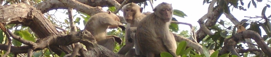
Fig IX: Long-tailed Macaque (Macaca fascicularis)
Long-tailed macaques Macaca fascicularis (Fig IX) were found in relatively large numbers in comparison to the size of the site, and following from Dr Suchinda Malaivijitnond et al.’s report, we also confirmed cases of genetic and behavioural stress from the dense numbers. On the 2nd March 2012, during provisioned 09:00 feeding by the local Tetsaban we counted the population to be at least 698 individuals. M. fascicularis was found throughout the woodland and hardstand habitat during daylight hours, although they tended to occupy the western hardstand in mixed sex ‘groups’ up to 100+ in number, whilst lone and small n3-5 groups of males were observed further away, around the perimeter habitats of the mixed sex groups. On multiple occasions during dark hours before 06:30 and after 19:00, it was observed that they roost in the tree canopies of the woodland in the west & east. Further details on local M. fascicularis distributions are found in Section 3 of this report. In addition to the artificial provisioned and visitor feeding, we observed M. fascicularis naturally feeding on Dipterocarpaceae, golden shower Cassia fistula and various other tree fruits. Whether this natural food resource is abundant enough to support the local population or contains enough nutrition needs further investigation.
In addition to the M. fascicularis population, the woodland habitat is suitable for the nesting and feeding of many birds specie, such as white rumped-shama Copsychus malabaricus and common myna Acridotheres tristis. On occasion bird watchers have visited the site during observation, suggesting the M. fascicularis population is not the only fauna of interest for visitors. The site also contains an abundant and diverse number of lizards of various species including monitor lizards (Varanus bengalensis) and geckos (Gekko spp.), butterflies (numerous species including grey pansy Junonia atlites and blue tiger Tirumala limniace), bees (honeybee Apis sp. and bumble Bombus sp.), various ants (Formicidae) species, unidentified termites (Blattodea) specie/s and a small population of Indochinese ground squirrels (Menetes berdmorei). There have been reports by locals of snakes on the site, but only one brief observation was made during the period of an unknown species, suggesting they seem to be rare on site (or at least rare during this period). Whilst these species do not seem initially to attract visitor attention, they add to biodiversity of the site and may attract scientific interest, due to the ease of access and observation of these species in a naturalistic setting.
1.5 VISITOR IMPACT
The western side of the site receives daily visitation from locals and tourism, as well as being host to a multitude of annual festivals. The site contains many buildings for this purpose, either being cultural in nature (e.g. shrines & temple like) or to facilitate visitors (toilets & sheds for housing cleaning tools, Fig X). The most frequent visitation is from people coming to feed the macaques. A usual ‘trip’, lasts approximately 10 minutes, with a car stopping at the vendor stalls opposite the 2ndNorthern Gate to buy food, which they then hand out between the gate and the shrine located at the junction of the hardstanding. Apart from annual festivals, the locals can also be found in the site, engaging in such activities like collecting wood and gathering plants & small fauna. Although the high usage of the site produces a large amount of visible rubbish on site, the Tetsaban and local volunteers are actively engaging in cleaning duties. In contrast, the eastern side of the site receives little visitation and no festivities are held there. The occasional rubbish pile can be found amongst the scrub habitat. Whether this is from the surrounding farmland or fly-tipping is unknown.

Fig X: Toilet Facilities between 2ndNorthern gate & Shrine
1.6 SUMMARY
The site contains a large portion of woodland habitat, with smaller areas of dense ‘high’ scrub, open standing water/marginal vegetation, bare ground, and hardstanding. These areas may be of low nature conversation interest, but contain an array of fauna that may be of public and scientific interest.
Some species of Dipterocarpaceae are listed on the ICUN red list, although due to the abundance of the site species found in and around the surrounding areas, these are unlikely to be the same. In addition, it would be advised to run a phase 2 type habitat survey to gain more knowledge of the flora structure and its suitability in sustaining the M. fascicularis population. The local populace make a visible effort in maintaining the site, and due to their dedication it could be recommended to set up a ‘citizen scientist’ scheme, such as is found in sites of importance in the UK. This would help in gathering annual information once further species identification is discovered.
2. SITE MAP
Site Map
Key


visual representation of the map against google.com’s photographic map service

3.1 References
JNCC, (2010). Handbook for Phase 1 habitat survey – a technique for environmental audit. ISBN0 86139 636 7.
Prof. Dr. Suchinda Malaivijitnond, Report on Monkey Survey at Phana (Sept 2011)
3.2 Appendix
Figs XI-XIII: Documentation of sand/gravel (Fig XI) and bare (Fig XII) pathways. Fig XIII represents what is probably a dried-up waterway, converted into a bare path by locals/visitors.


Fig XI Fig XII Fig XIII
